
Garhwal Himalayas · Uttarakhand · 2026
3.5 KILOMETRES TO THE
HIGHEST SHIVA TEMPLE ON EARTH
A complete Tungnath trek guide from Chopta — route, cost, best time to visit, and everything we learned the hard way on a scooty, with average fitness, and no guide.
Why the Tungnath Trek Is Famous
There's a version of a Himalayan trek that doesn't ask much of you and still hands over something extraordinary. That's Tungnath. Three and a half kilometres of stone steps and forest, a couple of hours of steady walking, and you're standing in front of the highest Shiva temple on earth — prayer flags snapping in the wind, the Chaukhamba range sitting right there behind the roofline.
If you're looking for a Himalayan trek that's beginner-friendly, genuinely beautiful, and close enough to Delhi for a long weekend, this is one of the best places to start. Most people treat it as the warm-up to Chandrashila — but Tungnath is a complete, worthwhile trek in its own right, temple and all, even if you never take another step past it.
We rode a scooty from Rishikesh, camped overnight at Chopta, and took it one slow step at a time. Here's everything we learned.
It's not the longest or hardest trek in the Garhwal Himalayas — but it delivers a combination that's genuinely hard to find elsewhere: a thousand-year-old shrine at 3,680 m, a short and honest climb with no technical sections, easy access from Delhi, and a trailhead to Chandrashila summit right behind the temple. Doing Chopta + Tungnath together, even without pushing on to the summit, is one of the most rewarding half-day treks in Uttarakhand. It doesn't feel like a smaller version of something else. It feels complete.
Quick Trek Overview
| Trek Name | Tungnath Trek |
| Temple Altitude | 3,680 m (~12,073 ft) |
| Trek Distance | 3.5 km one way (Chopta to Temple) |
| Difficulty | Easy to Moderate |
| Best Time | Apr–Jun & Sept–Nov (clear skies), Dec–Feb (snowfall) |
| Base Camp | Chopta, Uttarakhand (~2,680 m) |
| Nearest City | Rishikesh (~220 km) |
| Trek Duration | Half day (3–4 hours round trip) |
| Permit Required | No (as of 2025) |
| Trek Type | Day trek (extendable to Chandrashila) |
Best Time to Visit — Season by Season
Snow is melting on the upper stretch. Rhododendrons bloom red and pink lower down. Trails can be muddy in patches, but the colour makes up for it. Moderate crowds, good for photography.
The most reliable window of the year. Trails fully clear, meadows green, mornings cool. Tea stalls near the temple are open. This is when we trekked — 10 June 2024 — conditions were genuinely comfortable.
Best avoided. Heavy, sustained rainfall across Garhwal. Stone steps get slippery, cloud cover regularly swallows the temple, and the approach road can face landslide-related delays.
The golden window. Skies are at their sharpest, and the Chaukhamba and Kedarnath ranges look closer than they have any right to. The season most people recommend for clear views.
December – February ❄️ — Best for Snowfall
Chopta and the trail transform completely under snow. Tungnath's idol is moved down to Ukhimath for the season and the temple itself closes, but the climb becomes a genuine winter trek — quiet, white, and considerably more demanding. Go prepared, or go with a guide.
TravelCoda Tip: Peak snowfall on the route runs from December through February — January typically sees the deepest accumulation. If you'd rather have clear skies and cold air without full winter conditions, late October to mid-November is the sweet spot.
How to Reach Chopta
Delhi → Haridwar / Rishikesh (by bus or train, ~5–6 hours) → Chopta (~220 km from Rishikesh, 8–9 hours by road)
Many trekkers land in Haridwar first, since it's a major railhead with strong connections across North India, then move on to Rishikesh before continuing into the hills. Key waypoints from Rishikesh: Devprayag → Rudraprayag → Ukhimath → Chopta.
Transport Options from Rishikesh
| Option | Approx. Cost | Notes |
|---|---|---|
| Rented Scooty / Bike | ₹700–₹1,000/day | Scenic, budget-friendly, needs an early start |
| Shared Taxi | ₹600–₹900/seat | Runs to Ukhimath, then local transport onward |
| Private Cab | ₹4,000–₹6,000 one way | Comfortable, direct |
| State Bus (GMOU) | ₹200–₹400 | Cheapest, but slow and infrequent |
From our experience: We rented a scooty in Rishikesh and rode to Chopta — one of the better decisions of the trip, and genuinely scenic the whole way. But we made the mistake of leaving late, around 2 PM, and had to stop partway once fatigue and the hour caught up with us. If you're riding, start by 7–8 AM at the latest.
⛽ Fuel warning: there's a long stretch approaching Chopta with no petrol pumps — we ran low ourselves and ended up buying fuel from a local shop at nearly 3× the normal price. Fill up completely at Ukhimath before continuing, and carry a little extra if you can.
Chopta: Your Base Camp
Chopta sits at roughly 2,680 m, inside the Kedarnath Wildlife Sanctuary. It's small — a handful of camps, a few basic shops, and a trailhead leading straight up toward Tungnath. There's no electricity at most camps, no ATMs, and limited phone signal.
Warm bedding, basic meals included. What most trekkers choose.
Limited beds — book well in advance.
A few basic options close to the start of the trail.
We stayed at a tent camp. Before leaving at 4 AM, we left our heavy bags there and only carried a small daypack with water, snacks, and a first-aid kit. There's no reason to lug a full bag up the mountain for a trek this short.
Quick advice: carry a fully charged powerbank. There's no electricity at most camps in Chopta, and cold weather drains phone batteries faster than you'd expect.
Food Options in Chopta and Along the Trail
Chopta's food scene is basic by design — a meadow settlement, not a market town, and that's part of its appeal. Most camps serve simple home-style meals: dal, rice, roti, seasonal sabzi, and Maggi at almost any hour. A handful of small dhabas near the trailhead add hot chai and omelettes for an early breakfast. On the trail itself, seasonal tea stalls (roughly May through October) sell chai, Maggi, and biscuits — useful for a short break, not a proper meal.
Food tip: carry your own snacks regardless of season. Dry fruits, energy bars, and glucose biscuits travel well and don't depend on anyone else being open.
Detailed Trek Route: Chopta to Tungnath
The full route is 3.5 km one way — from the Chopta meadow, through forest, and up to the temple courtyard. It has one clear character shift roughly halfway through.
The Climb
The trail begins right at the edge of the Chopta meadow, and it climbs immediately — no warm-up. The first kilometre is the steepest stretch of the whole route: stone steps cutting through dense oak and rhododendron forest, gaining height fast enough that most people pause at least once before the tree line breaks.
Past that first push, the forest thins into open bugyal — high-altitude meadow — and the gradient eases into a long, steady pull. The Chaukhamba and Kedarnath ranges start appearing behind you with every switchback, and the horizon keeps expanding the higher you go.
There's no technical section anywhere and no route-finding required — a clearly marked, well-worn stone path start to finish. Most trekkers reach the temple in 1.5 to 2 hours going up, with the descent taking noticeably less. Ponies are available from Chopta at roughly ₹800–1,200 one way.
The Temple
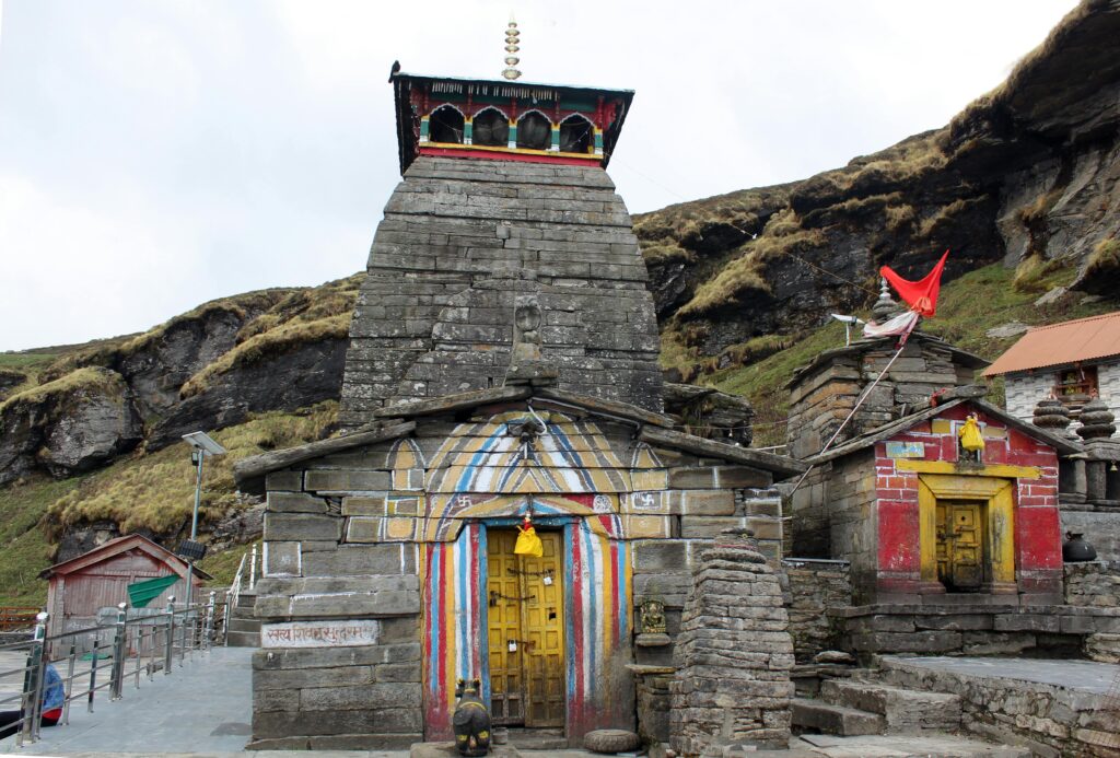
Tungnath sits inside a compact stone courtyard, its pagoda-style roof and carved doorway framed by snow-capped peaks on almost every side. Whether or not you're religious, it's a striking place to stand — an ancient structure at altitude, prayer flags moving in wind that never really stops up there.
Local belief holds that the Pandavas, seeking forgiveness after the Mahabharata war, pursued Shiva across these mountains in the form of a bull. Each time they closed in, he dove further into the earth, scattering across five locations — the Panch Kedar. Tungnath is said to be where his hump surfaced.
Total distance: ~3.5 km one way — up: 1.5–2 hrs, down: 1–1.5 hrs
Honest pacing, not the brochure number
Honest note: we started at 4 AM hoping to reach the temple for sunrise — we didn't. Our fitness level was average, and the climb took longer than expected, even on a trail this short. We continued on to Chandrashila afterward and were back at Chopta by around 2 PM. Budget generously, and don't treat the "easy to moderate" rating as a reason to skip fitness prep.
Trek Difficulty
The Tungnath Trek is classified as Easy to Moderate. No technical climbing, no ropes, and no prior trekking experience required. But altitude affects stamina in ways flat-ground fitness doesn't fully prepare you for.
If this is your first trek, the 3.5 km distance will feel longer than it sounds. Even a pace that feels easy at sea level will feel slower above 3,000 m — that's normal. We went in with average fitness and it genuinely showed on the way up; take breaks without guilt, drink water steadily, and don't try to match a faster trekker's pace.
A week or two of basic cardio — walking, stairs, incline walking — before attempting the trek makes a real difference, not because it's dangerous without it, but because you'll enjoy the temple and the views far more without exhaustion working against you.
Cost Breakdown — Budget Travel from Delhi
| Expense | Approx. Cost |
|---|---|
| Delhi to Rishikesh (bus) | ₹300–₹500 |
| Scooty rental in Rishikesh | ₹700–₹1,000/day |
| Fuel (Rishikesh–Chopta return) | ₹900–₹1,500 |
| Camp stay in Chopta (1 night) | ₹500–₹800/person |
| Meals at Chopta | ₹150–₹300/meal |
| Trek entry fee | ₹0 (as of 2025) |
| Optional pony (one way) | ₹800–₹1,200 |
| Miscellaneous (snacks, chai, medicines) | ₹200–₹400 |
| Total per person (budget) | ~₹2,800–₹4,200 |
This is one of the more affordable short Himalayan treks accessible from Delhi. A private cab instead of the scooty route adds roughly ₹2,000–₹3,000 per person to the total.
Personal tip: we underestimated fuel availability on this route and ended up buying petrol from a roadside local shop at nearly 3× the normal price. Fill your tank completely before leaving Ukhimath, and carry a little extra fuel if you can.
Suggested 1-Day Itinerary
Assumes an overnight stay in Chopta the evening before.
AM
Water, snacks, layers only. An early start gives the best shot at catching the temple before sunrise, though at an average pace you may not quite make it — that's fine, the early light is still worth it.
7:30
Have something warm if the stalls are open.
AM+
If extending the day, this is where most of your remaining time will go.
PM
A realistic finish time at an average pace, not the 3–4 hour round trip the distance alone suggests.
ning
Consider Deoria Tal or Kartik Swami Temple in the afternoon if energy allows.
TravelCoda Tip: Don't rush straight back to the highway after the trek. Half a day of buffer around Chopta is worth building in.
Packing List
- Layered clothing (base, fleece, windproof outer)
- Trekking shoes with ankle support
- Sunscreen SPF 50+
- Sunglasses
- Powerbank, fully charged
- Water bottle (at least 1 litre)
- Energy snacks — dry fruits, chocolate, biscuits
- Painkillers, ORS, personal medication
- Headlamp or torch
- Cash — no ATMs near Chopta
- Woollen thermals (top and bottom)
- Snow gaiters
- Woollen gloves and a balaclava
- Microspikes for the upper stretch
- Hand warmers
Weather, Network & Permits
Weather Conditions at Tungnath
| Month | Day Temp | Night Temp | Conditions |
|---|---|---|---|
| March–April | 8–14°C | 0–5°C | Partly cloudy, melting snow |
| May–June | 12–18°C | 5–10°C | Clear and pleasant |
| July–August | 10–14°C | 5–8°C | Rainy, foggy — avoid |
| Sept–November | 10–16°C | 0–5°C | Clear skies, best views |
| December–February | -2 to 4°C | -12 to -2°C | Heavy snowfall, temple closed |
For live weather updates before your trek, check the India Meteorological Department.
Mobile Network & ATMs
- BSNL has the most consistent coverage across the route and at Chopta.
- Airtel and Jio work in patches — reliable in Ukhimath, spotty near Chopta, largely absent above the temple.
- Expect no signal at the temple itself. Download offline maps before setting out.
- No ATMs near Chopta — nearest is Ukhimath (~25 km). Withdraw cash in Rishikesh.
Permits
No trekking permit is currently required for Tungnath as of 2025 — the trail is open to independent trekkers without registration. Since the route passes through the fringe of the Kedarnath Wildlife Sanctuary, it's worth checking current rules with the Uttarakhand Forest Department before you go, as sanctuary regulations can change.
Safety Tips
- Share your plan before leaving — route, camp location, expected return time.
- Ask locals when in doubt — camp owners and shopkeepers know current trail and weather conditions better than any app.
- Don't trek alone in winter — the trail can vanish under fresh snow.
- Watch for altitude symptoms — persistent headache, nausea, or disorientation are signs to stop and descend.
- Stay on the marked trail, particularly near the temple where the ground opens out.
- Turn back if lightning or a sudden storm rolls in on the open meadow stretch.
Golden Hour at Tungnath
Reaching the temple in the first hour after sunrise, before any wind picks up, is when Tungnath is at its best. The stone catches early light, the peaks behind it are still sharp-edged against a clean sky, and the courtyard is usually near-empty.
Most people aiming for this window leave Chopta by 5:00–5:30 AM, reaching the temple by roughly 6:30–7:00 AM at a brisk pace. We left at 4 AM hoping for exactly this, and still didn't make it in time — average fitness meant a slower climb than planned. We were disappointed for about five minutes, and then the temple in full morning light turned out to be plenty.
Winter Trekking Tips (December – February)
Winter Tungnath is a different trek entirely. The trail disappears under snow, the temple's idol is relocated to Ukhimath, and the site itself closes for the season — but the climb through a silent, white landscape has its own appeal for prepared trekkers.
- Hire a local guide — the trail may be invisible under snow, and this isn't optional advice for winter.
- Start early — overnight snow hardens by morning, making footing more predictable than soft afternoon snow.
- Layer properly — thermals under everything; you can remove layers, not add what you didn't pack.
- Microspikes on the upper stretch — the path can turn genuinely icy near the top.
- Build in extra time — everything takes longer in winter conditions.
- The temple is closed — this follows the Char Dham calendar; plan around it rather than against it.
"The mountain isn't going anywhere. Go when you're ready — and leave it as you found it."
On responsible travel in a working sanctuary
Extending to Chandrashila and Other Nearby Places
Tungnath is rarely the final stop for people who make it this far. The trail to Chandrashila summit begins right behind the temple and continues for another 1.5 km, gaining roughly 450 more metres to reach 4,130 m — the reward being a single 360° sweep of Nanda Devi, Trishul, Chaukhamba, and Kedar Dome. Our full Chandrashila Trek Guide covers that stretch, route timing, and winter conditions in detail.
- Deoria Tal — a high-altitude reflection lake ~28 km from Chopta, the Chaukhamba massif mirrored on calm mornings. A natural horizontal counterpart to Tungnath's vertical climb.
- Kartik Swami Temple — another hilltop temple with wide Himalayan views, considerably less crowded than Tungnath. A short drive, then a 30-minute climb.
- Chopta itself — worth slowing down for rather than treating purely as a trailhead.
- Rishikesh — the natural staging point on either end of this trip.
You've come 220 km to get here. Give yourself the time to see more than the temple.
Frequently Asked Questions
Yes. It's classified Easy to Moderate and requires no technical skill. First-timers should expect the climb to feel a little longer than 3.5 km suggests, and some basic cardio prep beforehand helps.
Technically, but it makes for a very long day — roughly 8–9 hours of driving each way around a 3–4 hour trek. An overnight stay in Chopta makes the trip far more comfortable and considerably safer.
No, not in the clear-season months — the trail is well-marked throughout. In winter, when snow can obscure the path, a local guide is strongly recommended.
December to February, with January typically seeing the heaviest accumulation. The first snow can arrive as early as mid-to-late November.
Yes, from May to October there are a few tea and snack stalls along the route. In winter they close — carry all food and water from Chopta.
No. It follows the Char Dham calendar and is typically open from May to November, with the idol relocated to Ukhimath for the winter months.
Roughly 440–470 km by road, with the Rishikesh-to-Chopta leg alone covering about 220 km.
Yes, and most people do. The Chandrashila trail begins directly behind the temple, adding roughly 1.5 km and 1–1.5 hours to reach the summit.